
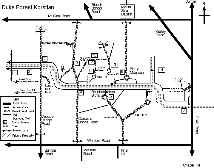
1. Power line crossing creek. Two steel cables crossing creek just east, probably once used as a foot bridge or ferry.
2. Mill ruins. Dam ruins some distance upstream above rapids with mill race to mill foundation ruins below rapids.
3. Wooden bridge. Stairs down to creek side trails on both sides of creek on both sides of road. Once encountered marine biologists (Duke students) gathering marine invertebrate samples east. Moderate trail east on south side leads to concrete bridge.
4. Concrete bridge. Often under water. Trail east on north side of creek leads to a good climb up a bluff with good overlook of bridge and creek. Moderate trail west on south side leads to wooden bridge. Easy trail east on south side leads to rhododendron bluffs.
5. Rhododendron Bluffs. Arguably the most beautiful overlook over the creek. Road from Whitfield Road leads through a Southern Pine Beetle treatment area and ends at circle with trash containers. Sign: “ Erosion Control & Trail Restoration Project, National Civilian Conservation Corps, Team Action-R2”. Steep trail with steps leads down to creek next to rhododendron covered cliffs. However, since the tree damage from Fran, the 2000 blizzard and 2002 ice storm, the tree canopy around the bluffs has opened up. The number of mountain laurels on the bluffs has diminished greatly. Halfway down there is a wide ledge that overlooks the creek. At the base of the climb, an easy trail leads east to the beaver ponds. After climbing over the rocks at the base of the bluff, an easy trail leads west to concrete bridge.
6. Piney Mountain. Highest overlook of creek valley. Road from Mt. Sinai Road ends at circle. Easy trail west leads down to minor creek valley which then leads to main creek valley. Moderate trail east leads down to creek valley trail. Difficult climb up from creek valley to circle.
7. Beaver Ponds. The creek splits encompassing a fairly wide island. There have been a succession of beaver dams on the main part of the creek that floods the creek and Piney Mountain Creek that enters from the north. It appears that Fran has (at least for now) destroyed the beaver dams. The south side of the curve encompasses a multiple acre cleared area, somewhat swampy, purpose and history unknown. There are easy trails on both sides of the creek. The south side trail leads west to Rhododendron Bluffs. There is considerable Fran damage on this trail near the old beaver dams. The north side trail turns north at Piney Mountain Creek and heads east to the entrance at the Erwin Road bridge.
8. Near the entrance at the Erwin Road bridge is found the largest dam ruin encountered on the creek. The south side of the creek is mainly sheer bluffs into the water. There are several private homes on top of those bluffs. Below one such home is a small dam ruin in the creek. Easy trail on the north side to the beaver ponds.
9. Southern Pine Beetle Infestation 1993. Salvaged 1994. (Burned 1994. Replanted with white pine 1995.) Pine Release 1997.
10. Controlled burn area.
11. Cemetery. Two readable headstones: "In Loving Memory of a Beautiful Lady, Sarah Jane Schuhart Carothers Oct. 5, 1931- Jan 27, 1986" and "In Memory of Mann P Jenkins who was born June 15th 1795 Died Jan 25th. 1856". Older headstone on concrete footing, indicating modern preservation. Various standing stones, probably unmarked graves. Near circle above bluff overlook of concrete bridge.
12. Loblolly Pine. Planted 1934. Thinned 1962. Harvested 1990. Pine tree Release 1993. Pre-commercial Thinning 1998.
13. Southern Pine Beetle infestation 1992. Salvaged 1993. Burned 1994. Replanted with short leaf and white pine 1995.
14. Fran created a log bridge across Piney Mountain Creek at this point. The west side trail peters out due to Fran damage just north of the log bridge. The east side trail leaves Duke Forest through an old barbed wire fence and peters out. There are houses to the east and one can access their long driveway and walk out to Mt Sinai Road.
15. Farm site. Stone foundation and fireplace evident. Old bottles.
Korstian Division Topo Map| ©2025 Dave Filpus | |
This work is licensed under a Creative
Commons Attribution-NonCommercial-NoDerivs 2.5 License. |